The Trail

Friday, May 27, 2011
May 30th Whiskey Dick
This weeks hike will be at Whiskey Dick Wildlife Area on Sunday. Click on the link for the information and directions. This will be a hike with the family, looking for wildlife and wild flowers. I plan on getting there around 9:00am.
Saturday, May 21, 2011
Mt. Si Trail run/Hike
 |
| Trailhead Map. |
 |
| Gps Track and elevation plot. |
The trail was in great shape all the way to the top. There was only a little snow at the top but it was well packed down. There were a lot of people with dogs on the trail most were off leash, so if your not a dog person probably not a trail for you.
 |
| Elevation plot with stats. |
 |
| Panorama looking down half way up the haystack. |
 |
| Looking down on North Bend from Mt. Si |
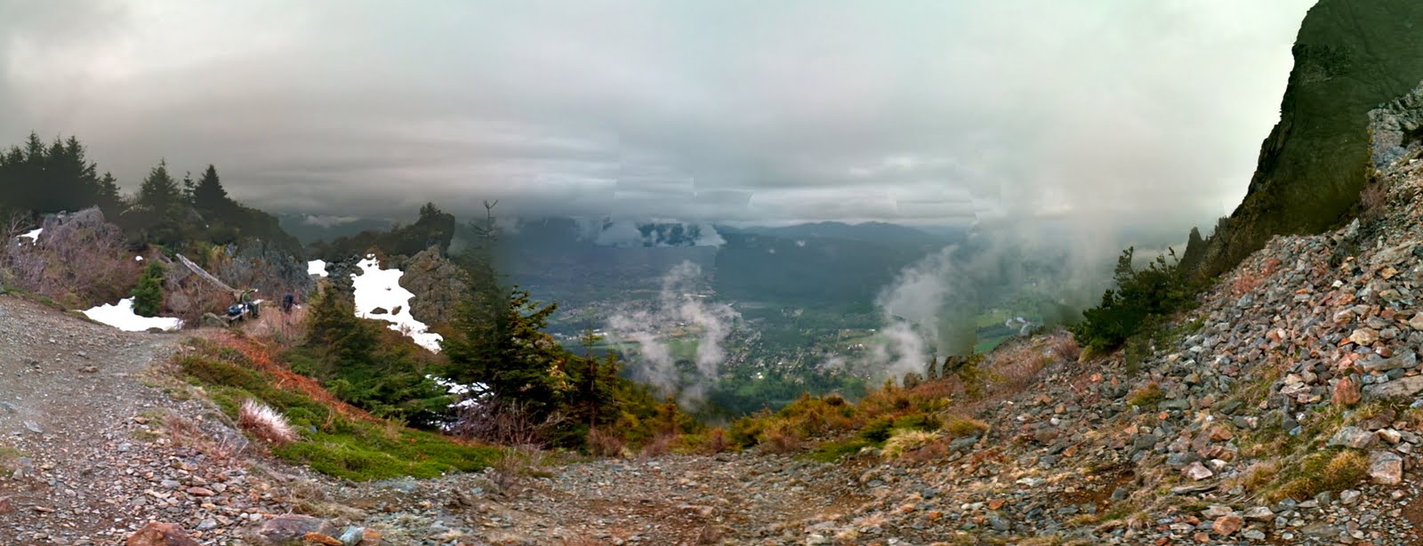 |
| Panorama from Mt. Si |
 |
Wednesday, May 18, 2011
May, 21st Hike
This coming Saturday the plan is Mount Si. I plan on being there at 7:30am, come join me. Message me on Facebook or here and we can arrange rides and carpools.
Saturday, May 14, 2011
May, 14th Hike. Lake Twenty-Two
Today I wanted to hike to Monte Cristo the old mining town, however the road was closed several miles from the trailhead. On my way there I passed a few other trails to various destinations. So I pulled into the parking lot of the Lake Twenty-Two trailhead. I'm glad I did this was a cool little hike with great scenery and was a well maintained trail.
 |
| Lake Twenty-Two trailhead. |
 |
| Lake Twenty-Two trail info and map. |
 |
| Big old tree off the trail. |
 |
| One of many water falls and pools on this hike. On a hot day these would be awesome. |
 |
| Open rocky area this was switch backs for about .75 miles. |
 |
| The trail though the snow. |
 |
| Spring trying to brake through. |
 |
| The creek just before the lake check out how thick the snow still is. |
 |
| Panorama shot of Lake Twenty-Two and the surrounding mountains. |
 |
| If you look closely you will see little streams of water coming of the cliffs . Click the photos to make them full size. |
This was a great hike!
 |
| GPS track and elevation. |
Wednesday, May 11, 2011
Wallace Falls Hike May, 7th.
Wallace Falls is located in Gold Bar, WA. I lived in Gold Bar for five years and always thought about going to Wallace Falls but never did. This was one of the motivating factors for wanting to go there. It is also listed on Washington Trail Associations website as being a good hike in the spring, plus it is listed as a good hike on a rainy day(its a waterfall thing).
 |
| Wallace Falls Tail with Elevation. |
We made some quick stops in the morning and arrived at 7:45am. On arrival the weather seemed better than I had anticipated. We still packed for the rain, it happens. The temperature was in the upper 40's, whoo-who.
 |
| At the Wallace Falls trail head. |
We set off for the upper falls at 8:00. The fist half mile of the trail is on a gravel road under power lines, not exactly nature at it finest but it did provide clear views of the surrounding snow capped mountains. Once we got off the road and in to the woods it was beautiful.
 |
| At the beginning of the trial. |
The trail was in really great shape. Some small puddles and mud here and there. We took our time stopping at all the lookouts along the way.
 |
| The middle falls in the distance. |
 |
| The lower falls. |
 |
| The larger of the three main falls, this is the middle falls. |
 |
| The upper falls. |
It was getting pretty wet at the upper falls. We had made it to our destination without any issues, only seeing three people on the way up. It had taken one hour and ten minutes to make the 2.6 mile hike with with lots of stops to take in the sights. The elevation gain was 1300ft to the upper falls.
 |
| Poncho time at the upper falls. |
On the way back down we passed 25-30 people headed up the trail. It was wet but we came prepared. We left around 10:30am. What a great morning hike.
Thursday, May 5, 2011
May 8th,9th Weekend trials
This Saturdays hike will be a short easy hike up to Wallace Falls. Its Perfect for people looking to get into the swing of things. I have chosen this location because its easy and there is still a good amount of snow starting at 2000ft. I do not want to deal with snow and the rain. The trail opens up at 7:45am I plan on being there then.
Sundays trail run will be at Lord Hill, Its close and lots of options as far a distances go. I'll be hitting the trail around 1:30pm - 2:00pm, after I done with playing for worship at Goldcreek. You can watch the live services at 9:00, 10:30, and 12:00.
Check out the links to the locations, let me know if you need a ride. It should be a fun weekend even if the weather sucks. Come join me.
Thank you,
David.
Monday, May 2, 2011
First trail run of the year
So for the first run on the year I decided I would run on a trail that I was somewhat familiar with. I even though I have not set foot on this trail in 10 plus years. So off to the trail-head I went.
Lake Serene
The trail starts outside the town of Index just off highway2. The length of the trail is about 7 miles to the lake and back. The elevation gain is almost 2000ft. There was a good amount of people on the trail the parking lot was 85%-95% full, not bad considering that this was one of the only nice days that we have had in area this year.
The Gear
GPS- My newly acquired Garmin Oregon 450.
Small flash light- There is a old mine I thought I might want to go in, it was pretty cool 10 years ago.
My old FOX water camel-backpack- Carries water and TP and everything else.
Shoes- NB Minimus. wrong shoe for this trip.
Phone camera combo
Parked the Mighty Smart and started rolling up the trail
The first part of the trail is on the old road that takes you up to where the old trail started. There was also a mine there15-20years ago. Its was easy going. Where the old road ended and the new trail started was nearly seamless because of vegetation growth and erosion, amazing.
Farther up the trail splits, to the right takes you to the falls, go left and your going to the lake. Were the split is according to my gps is near where the Mine located, so this is close to were the old parking lot use to be. Back in the day you would climb along the falls to the lake, it was much more direct. It was also dangerous, in fact all the trail books would not give the location of Lake Serene until the trail was upgrade.
I took the fork to the left and headed to the lake, the run was fairly easy at this point. I stoped to take a few pictures of some water falls the first one was at a bridge.
Then a few hundred yards down the trail I stopped at another water fall with a nice pool beneath it
From here the trail stated to climb up rather quickly(see elevation chart),on granite rock rubble with some stairs mixed in on the switch backs. My legs were not so happy with me but I pushed on. About one mile from the falls is were snow, slush and, mud were on the trail as well.
Some places were pretty slick, this made me wish I had some chains for my shoes. I continued on and up crossing a few open snow fields. When I started crossing this one(picture below), I heard a distant rumble of an avalanche.
This can make you a bit nervous when crossing these open areas because they are not exactly flat and it was getting warm rather quickly.
400-500 yards passed the above picture and I was at the lake.
While at the lake I rested a bit, had a seat on the log bridge and enjoyed the sights and the sounds. It was awesome every minute or so you could hear and see avalanches coming off the mountain. Some were like water falls of snow. The sound was like thunder, very cool to be there for the show.
The way back down was quick and uneventful. I was wishing that I had worn shoes with a rock plate on the bottom. The granite rocks on the trail were all pointy side up and I was wearing a thin, minimal trail running shoe.
Overall it was a great run and a great day. Time on the trail was an 1:30. I spent an hour up top resting and watching so the total time was 2:30. Good times
You and check out the trial run through map my run, Click Here
Thanks for reading my blog,
David.
Lake Serene
The trail starts outside the town of Index just off highway2. The length of the trail is about 7 miles to the lake and back. The elevation gain is almost 2000ft. There was a good amount of people on the trail the parking lot was 85%-95% full, not bad considering that this was one of the only nice days that we have had in area this year.
 | ||
| Map and slope of trail. This was made using map my run with data collected from my GPS. |
GPS- My newly acquired Garmin Oregon 450.
Small flash light- There is a old mine I thought I might want to go in, it was pretty cool 10 years ago.
My old FOX water camel-backpack- Carries water and TP and everything else.
Shoes- NB Minimus. wrong shoe for this trip.
Phone camera combo
 |
| The Mighty Smart, and some dude doing some cold stretching for the hike. |
The first part of the trail is on the old road that takes you up to where the old trail started. There was also a mine there15-20years ago. Its was easy going. Where the old road ended and the new trail started was nearly seamless because of vegetation growth and erosion, amazing.
Farther up the trail splits, to the right takes you to the falls, go left and your going to the lake. Were the split is according to my gps is near where the Mine located, so this is close to were the old parking lot use to be. Back in the day you would climb along the falls to the lake, it was much more direct. It was also dangerous, in fact all the trail books would not give the location of Lake Serene until the trail was upgrade.
I took the fork to the left and headed to the lake, the run was fairly easy at this point. I stoped to take a few pictures of some water falls the first one was at a bridge.
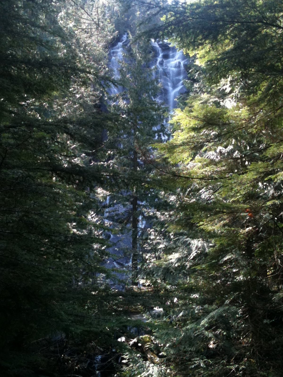 |
| Waterfall though the trees. As seen from the second small bridge on the Lake Serene trail. |
 |
| Stream below the waterfall. As seen form the second bridge on the Lake Serene trail. |
 |
| Cool waterfall along Lake Serene trail. |
 |
| Pool below waterfall on the Lake Serene trail. |
Some places were pretty slick, this made me wish I had some chains for my shoes. I continued on and up crossing a few open snow fields. When I started crossing this one(picture below), I heard a distant rumble of an avalanche.
 | |
| Open snow field crossing on the Lake Serene trail. |
 | ||||
| Beautiful view from an open snow field on the Lake Serene trail. |
 | |
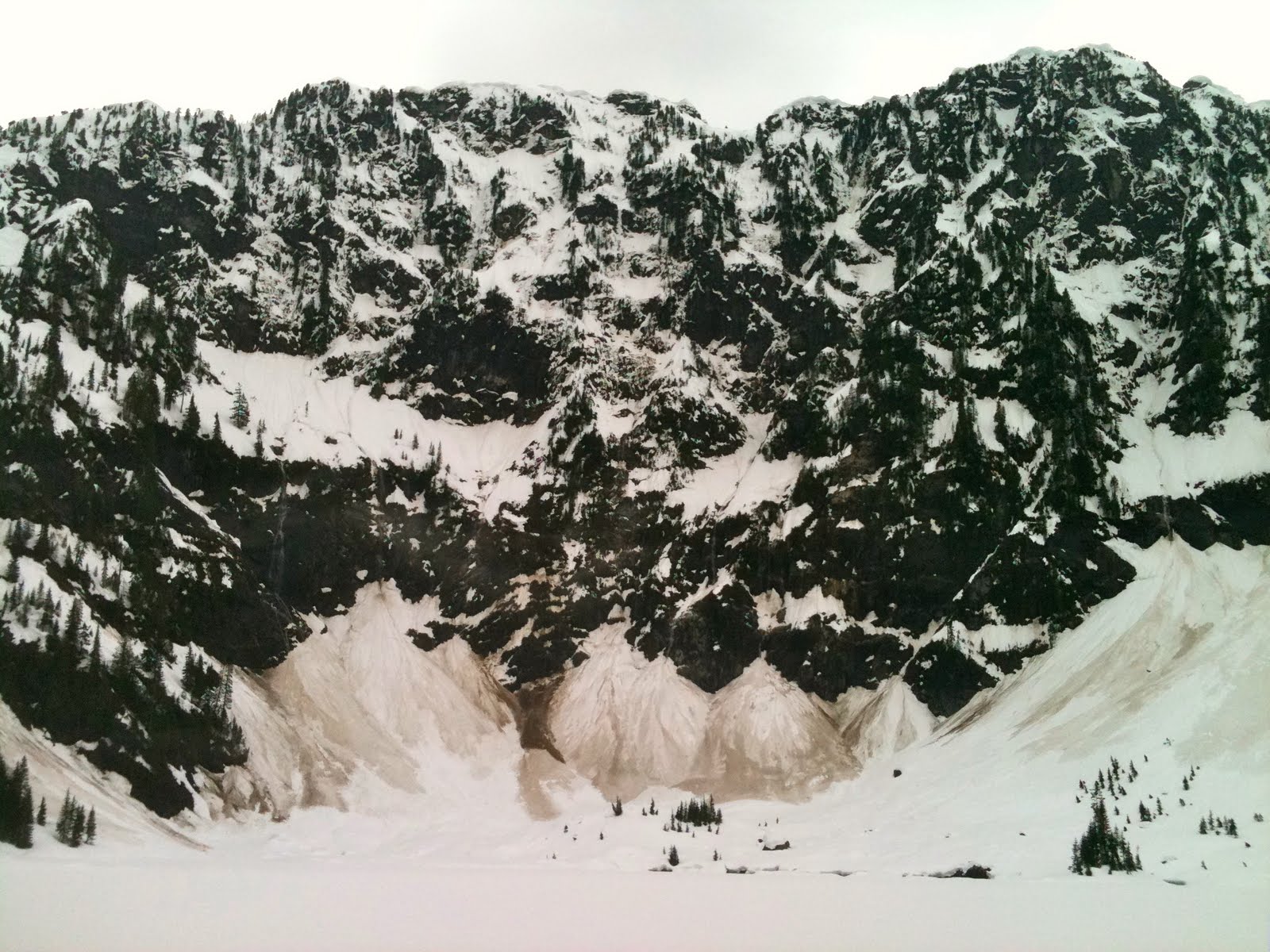
| Lake Serene, I used Photosynth on my phone to create this picture. |
 | |
| In the center you can see a small avalanche falling from the cliffs. Lake Serene |
Overall it was a great run and a great day. Time on the trail was an 1:30. I spent an hour up top resting and watching so the total time was 2:30. Good times
You and check out the trial run through map my run, Click Here
Thanks for reading my blog,
David.
Subscribe to:
Comments (Atom)